Tibet Autonomous Region
| Tibet Autonomous Region | |||||||||
|
|||||||||
| Abbreviations: 藏 (pinyin: Zàng) | |||||||||
 |
|||||||||
| Origin of name | From the Arabic توبات Tibat of unknown origin. cf. 土蕃 Tǔbō | ||||||||
| Administration type | Autonomous region | ||||||||
| Capital (and largest city) |
Lhasa | ||||||||
| CPC Ctte Secretary | Zhang Qingli | ||||||||
| Chairman | Padma Choling | ||||||||
| Area | 1,228,400 km2 (474,300 sq mi) (2nd) | ||||||||
| - Latitude | {{{Latitude}}} | ||||||||
| - Longitude | {{{Longitude}}} | ||||||||
| Population (2009) - Density |
2,910,000 (32nd) 2.2 /km2 (5.7 /sq mi) (33rd) |
||||||||
| GDP (2009) - per capita |
CNY 44.1 billion (32st) CNY 15,141 (28th) |
||||||||
| HDI (2008) | 0.630 (medium) (31st) | ||||||||
| Ethnic composition | 92.8% Tibetan | ||||||||
| Prefecture-level | 7 divisions | ||||||||
| County-level | 73 divisions | ||||||||
| Township-level* | 692 divisions | ||||||||
| ISO 3166-2 | CN-54 | ||||||||
| Official website http://www.xizang.gov.cn/ |
|||||||||
| Source for population and GDP data:
《中国统计年鉴—2005》 China Statistical Yearbook 2005
Source for nationalities data:
ISBN 7503747382 《2000年人口普查中国民族人口资料》 Tabulation on nationalities of 2000 population census of China
*As at December 31, 2004ISBN 7105054255 |
|||||||||
| Template ■ Discussion ■ WikiProject China | |||||||||
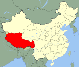
The Tibet Autonomous Region (TAR), Tibet for short, also called Xizang Autonomous Region (Tibetan: ![]() ; Wylie: Bod-rang-skyong-ljongs; simplified Chinese: 西藏自治区; traditional Chinese: 西藏自治區; pinyin: Xīzàng Zìzhìqū) is a province-level autonomous region of the People's Republic of China (PRC) created in 1965.
; Wylie: Bod-rang-skyong-ljongs; simplified Chinese: 西藏自治区; traditional Chinese: 西藏自治區; pinyin: Xīzàng Zìzhìqū) is a province-level autonomous region of the People's Republic of China (PRC) created in 1965.
Within the People's Republic of China, Tibet is identified with the Autonomous Region, which includes about half of ethno-cultural Tibet, including the traditional provinces of Ü-Tsang and the western half of Kham. Its borders coincide roughly with the actual zone of control of the government of Tibet in 1950. The Tibet Autonomous Region is the second-largest province-level division of China by area (spanning over 470,000 sq mi/1,200,000 km2) after Xinjiang. Unlike other autonomous regions, the vast majority of inhabitants are of the local ethnicity.
Contents |
History
From 1912 to 1950, the present extent of the Tibet Autonomous Region (comprising Ü-Tsang and western Kham) was ruled by the government of Tibet headed by the Dalai Lama. Other parts of ethno-cultural Tibet (eastern Kham and Amdo) had not been under the administration of the Tibetan government since the mid-eighteenth century [1]; today they are distributed among the provinces of Qinghai, Gansu, Sichuan and Yunnan. (See also: Xikang province)
In 1950, the People's Liberation Army invaded the Tibetan area of Chamdo, crushing minimal resistance. In 1951, the Tibetan representatives, under Chinese military pressure, signed a seventeen-point agreement with the Chinese Central People's Government affirming China's sovereignty over Tibet. The agreement was ratified in Lhasa a few months later.[2][3] Although the 17-point agreement had provided for an autonomous administration led by the Dalai Lama, a "Preparatory Committee for the Autonomous Region of Tibet" (PCART) was established in 1955 to created a parallel system of administration along Communist lines. The Dalai Lama fled to India in 1959 and renounced the 17-point agreement. PCART was reorganized as the Tibet Autonomous Region in 1965, thus making Tibet an administrative division on the same legal footing as a Chinese province.
Western Government secret intervention into Tibet began before the 1959 CIA supported insurrection. British MI6 agent Sidney Wignall, in his recent autobiography, [4] reveals that he travelled to Tibet with John Harrop in 1955 posing as mountaineers. Captured by the Chinese authority, Wignell recalled that he was surprised to find two CIA agents were already under Chinese detention. Tibetan exiles trained in a CIA camp in Colorado clashed with Chinese forces in 1959 during the celebration of the Tibetan New Year, after which the 14th Dalai Lama, with CIA help, went into political exile in India. After 1959, the CIA trained Tibetan guerrillas and provided funds and weapons for the fight against China. However, the effort stopped when Richard Nixon decided to seek rapprochement with China in the early 1970s. Kenneth Conboy and James Morrison, in The CIA's Secret War in Tibet [5], reveal how the CIA encouraged Tibetan revolt against China — and eventually came to control its fledgling resistance movement. The New York Times reported on October 2, 1998 that the Dalai Lama's administration acknowledged that it received $1.7 million a year in the 1960s from the CIA, but denied reports that the Tibetan leader benefited personally from an annual subsidy of $180,000. The money allocated for the resistance movement was spent on training volunteers and paying for guerrilla operations against the Chinese, the Tibetan government-in-exile said.[6][7]
Geography
The Tibet Autonomous Region is located on the Tibetan Plateau, the highest region on earth. In northern Tibet elevations reach an average of over 4,572 metres (15,000 ft). Mount Everest is located on Tibet's border with Nepal.
The Chinese areas of Xinjiang, Qinghai and Sichuan lie to the north and east of the region. China has border disputes with the Republic of India to the south including the McMahon Line of South Tibet. The disputed territory of Aksai Chin is to the west, and its boundary with that region is not defined. Other countries to the south are Myanmar, Bhutan and Nepal. Tibet also shares a short southeastern border with Yunnan province.
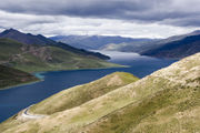
Physically, Tibet Autonomous Region may be divided into two parts, the "lake region" in the west and north-west, and the "river region", which spreads out on three sides of the former on the east, south, and west. Both regions receive limited amounts of rainfall as they lie in the rain shadow of the Himalayas, however the region names are useful in contrasting their hydrological structures, and also in contrasting their different cultural uses which is nomadic in the lake region and agricultural in the river region.[8] On the south it is bounded by the Himalayas, on the north by a broad mountain system. The system at no point narrows to a single range; generally there are three or four across its breadth. As a whole the system forms the watershed between rivers flowing to the Indian Ocean – the Indus, Brahmaputra and Salween and its tributaries – and the streams flowing into the undrained salt lakes to the north.
The lake region extends from the Pangong Tso Lake in Ladakh, Lake Rakshastal, Yamdrok Lake and Lake Manasarovar near the source of the Indus River, to the sources of the Salween, the Mekong and the Yangtze. Other lakes include Dagze Co, Nam Co, and Pagsum Co. The lake region is an arid and wind-swept desert. This region is called the Chang Tang (Byang sang) or 'Northern Plateau' by the people of Tibet. It is some 1100 km (700 mi) broad, and covers an area about equal to that of France. Due to its great distance from the ocean it is extremely arid and possesses no river outlet. The mountain ranges are spread out, rounded, disconnected, separated by flat valleys relatively of little depth.
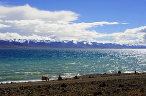
The country is dotted over with large and small lakes, generally salt or alkaline, and intersected by streams. Due to the presence of discontinuous permafrost over the Chang Tang, the soil is boggy and covered with tussocks of grass, thus resembling the Siberian tundra. Salt and fresh-water lakes are intermingled. The lakes are generally without outlet, or have only a small effluent. The deposits consist of soda, potash, borax and common salt. The lake region is noted for a vast number of hot springs, which are widely distributed between the Himalaya and 34° N., but are most numerous to the west of Tengri Nor (north-west of Lhasa). So intense is the cold in this part of Tibet that these springs are sometimes represented by columns of ice, the nearly boiling water having frozen in the act of ejection.
The river region is characterized by fertile mountain valleys and includes the Yarlung Tsangpo River (the upper courses of the Brahmaputra) and its major tributary, the Nyang River, the Salween, the Yangtze, the Mekong, and the Yellow River. The Yarlung Tsangpo Canyon, formed by a horseshoe bend in the river where it flows around Namcha Barwa, is the deepest, and possibly longest canyon in the world.[9] Among the mountains there are many narrow valleys. The valleys of Lhasa, Shigatse, Gyantse and the Brahmaputra are free from permafrost, covered with good soil and groves of trees, well irrigated, and richly cultivated.
The South Tibet Valley is formed by the Yarlung Zangbo River during its middle reaches, where it travels from west to east. The valley is approximately 1200 kilometres long and 300 kilometres wide. The valley descends from 4500 metres above sea level to 2800 metres. The mountains on either side of the valley are usually around 5000 metres high. [10][11] Lakes here include Lake Paiku and Lake Puma Yumco.
Government
The Tibet Autonomous Region is a province-level entity of the People's Republic of China. It is governed by a People's Government, led by a Chairman. In practice, however, the Chairman is subordinate to the branch secretary of the Communist Party of China. As a matter of convention, the Chairman has almost always been an ethnic Tibetan, while the party secretary has almost always been a non-Tibetan. The current Chairman is Padma Choling and the current party secretary is Zhang Qingli.[12]
Administrative divisions
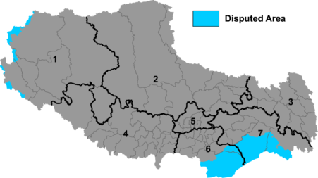
Tibet Autonomous Region is divided into one prefecture-level city and six prefectures. The indicated disputed territory is now the official territory of Union of India and is widely recognized. It has democratic Indian Government and democratic setup of bureaucracy.
| Map | # | Name | Hanzi | Hanyu Pinyin | Tibetan | Wylie | Administrative Seat |
|---|---|---|---|---|---|---|---|
 |
|||||||
| — Prefecture-level city — | |||||||
| 5 | Lhasa | 拉萨市 | Lāsà Shì | ལྷ་ས་གྲོང་ཁྱེར་ | Lha-sa Grong-khyer | Chengguan District | |
| — Prefecture — | |||||||
| 1 | Ngari | 阿里地区 | Ālǐ Dìqū | མངའ་རིས་ས་ཁུལ་ | Mnga'-ris Sa-khul | Gar County | |
| 2 | Nagqu | 那曲地区 | Nàqū Dìqū | ནག་ཆུ་ས་ཁུལ་ | Nag-chu Sa-khul | Nagqu County | |
| 3 | Qamdo | 昌都地区 | Chāngdū Dìqū | ཆབ་མདོ་ས་ཁུལ་ | Chab-mdo Sa-khul | Qamdo County | |
| 4 | Xigazê | 日喀则地区 | Rìkāzé Dìqū | གཞིས་ཀ་རྩེ་ས་ཁུལ་ | Gzhis-ka-rtse Sa-khul | Xigazê | |
| 6 | Shannan | 山南地区 | Shānnán Dìqū | ལྷོ་ཁ་ས་ཁུལ་ | Lho-kha Sa-khul | Nêdong County | |
| 7 | Nyingchi | 林芝地区 | Línzhī Dìqū | ཉིང་ཁྲི་ས་ཁུལ་ | Nying-khri Sa-khul | Nyingchi County | |
These in turn are subdivided into a total of seventy-one counties, one district (Chengguan District, Lhasa) and one county-level city (Xigazê).
Demographics
The Tibet Autonomous Region has the lowest population density among China's province-level administrative regions, mostly due to its mountainous and harsh geographical features.
In 2008 the Tibetan population was 5.4 million.[13] The ethnic Tibetans, comprising 92.8% of the population[14] mainly adhere to Tibetan Buddhism and Bön, although there is an ethnic Tibetan Muslim community.[15] Other Muslim ethnic groups such as the Hui and the Salar have long inhabited Tibet Autonomous Region. Smaller tribal groups such as the Monpa and Lhoba, who follow a combination of Tibetan Buddhism and spirit worship, are found mainly in the southeastern parts of the region.
Most Han Chinese in the TAR (6.1% of the total population)[14] are recent migrants, because all of the Han were expelled from Outer Tibet following the British expedition until the establishment of the PRC.[16] Ethnic Tibetan advocates fear an "acceleration" of Han migration since the 2006 completion of the Qingzang railway connecting the TAR to Qinghai Province.[17]
Towns and villages in Tibet
Economy

The Tibetans traditionally depended upon agriculture for survival. Since the 1980s, however, other jobs such as taxi-driving and hotel retail work have become available in the wake of Chinese economic reform. In 2009, Tibet's nominal GDP topped 44.1 billion yuan (US$6.5 billion), nearly more than four times as big as the 11.78 billion yuan (US$1.47 billion) in 2000. In the past five years, Tibet's annual GDP growth has averaged 12%.
While traditional agricultural work and animal husbandry continue to lead the area's economy, in 2005 the tertiary sector contributed more than half of its GDP growth, the first time it surpassed the area's primary industry.[18][19] The collection of caterpillar fungus (Cordyceps sinensis, known in Tibetan as Yartsa Gunbu) in late spring / early summer is in many areas the most important source of cash for rural households. It contributes an average of 40% to rural cash income and 8.5% to the TAR's GDP.[20] The re-opening of the Nathu La pass (on southern Tibet's border with India) should facilitate Sino-Indian border trade and boost Tibet's economy.[21]
In 2008, Chinese news media reported that the per capita disposable incomes of urban and rural residents in Tibet averaged 12,482 yuan (US$1,798) and 3,176 yuan (US$457) respectively. [22]
The China Western Development policy was adopted in 2000 by the central government to boost economic development in western China, including the Tibet Autonomous Region.
- Lhasa Economic and Technological Development Zone
Tourism
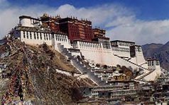
Tourists were first permitted to visit the Tibet Autonomous Region in the 1980s. While the main attraction is the Potala Palace in Lhasa, there are many other popular tourist destinations including the Jokhang Temple, Namtso Lake, and Tashilhunpo Monastery. Some areas remain restricted to tourists.
Airports
The civil airports in Tibet are Lhasa Gonggar Airport,[23] Qamdo Bangda Airport, Nyingchi Airport, and the Gunsa Airport.
Gunsa Airport in Ngari Prefecture began operations on July 1, 2010, to become the fourth civil airport in China's Tibet autonomous Region.[24]
Peace Airport for Xigaze prefecture is to be completed before the end of 2010.[25]
Nagqu Dagring Airport is expected to have the world's highest altitude airport by 2011 at 4,436 meters above sea level.[26]
See also
- China Tibetology Research Center
- List of universities and colleges in Tibet
Footnotes
- ↑ Grunfeld, A. Tom, The Making of Modern Tibet, M.E. Sharpe, p245.
- ↑ Gyatso, Tenzin, Dalai Lama XIV, interview, 25 July 1981.
- ↑ Goldstein, Melvyn C., A History of Modern Tibet, 1913-1951, University of California Press, 1989, p. 812-813.
- ↑ [A Spy On the Roof of the World]
- ↑ Morrison, James, The CIA's Secret War in Tibet, 1998.
- ↑ http://query.nytimes.com/gst/fullpage.html?res=9C0CEFD61538F931A35753C1A96E958260 Dalai Lama Group Says It Got Money From C.I.A. Retrieved on March 29, 2008
- ↑ http://www.fpif.org/briefs/vol5/v5n09tibet_body.html - Reassessing Tibet Policy http://www.fpif.org/pdf/vol5/09iftibet.pdf (same)
- ↑ "Tibet: Agricultural Regions". http://www.tew.org/geography/t2000.agricultural.html. Retrieved 2007-08-06.
- ↑ "The World's Biggest Canyon". www.china.org. http://www.china.org.cn/english/MATERIAL/185555.htm. Retrieved 2007-06-29.
- ↑ Yang Qinye and Zheng Du (2004). Tibetan Geography. China Intercontinental Press. pp. 30–31. ISBN 7508506650. http://books.google.com/?id=4q_XoMACOxkC&pg=PA30&dq=%22South+Tibet+Valley%22.
- ↑ Zheng Du, Zhang Qingsong, Wu Shaohong: Mountain Geoecology and Sustainable Development of the Tibetan Plateau (Kluwer 2000), ISBN 0-7923-6688-3, p. 312;
- ↑ "Leadership shake-up in China's Tibet: state media". Agence France-Presse. France: France 24. 2010-01-15. http://www.france24.com/en/20100115-leadership-shake-chinas-tibet-state-media. Retrieved 2010-07-29.
- ↑ http://ngm.nationalgeographic.com/geopedia/China#China%20by%20the%20Numbers
- ↑ 14.0 14.1 http://news.bbc.co.uk/2/shared/spl/hi/guides/456900/456954/html/nn5page1.stm
- ↑ Hannue, Dialogues Tibetan Dialogues Han
- ↑ Grunfeld, A. Tom (1996). The Making of Modern Tibet. East Gate Books. pp. 114–119.
- ↑ http://www.mcclatchydc.com/homepage/story/31913.html
- ↑ Xinhua - Per capita GDP tops $1,000 in Tibet
- ↑ Tibet posts fixed assets investment rise
- ↑ Winkler D. 2008 Yartsa gunbu (Cordyceps sinenis) and the fungal commodification of rural Tibet. Economic Botany 62.3. See also Hannue, Dialogues Tibetan Dialogues Han
- ↑ China and India to trade across Himalayas | World news | The Guardian
- ↑ Tibetans report income rises
- ↑ http://news.xinhuanet.com/english/2009-05/12/content_11357826.htm Gongkhar Airport in Tibet enters digital communication age
- ↑ [1]
- ↑ Tibet to have fifth civil airport operational before year end 2010
- ↑ World's highest-altitude airport planned on Tibet
Further reading
- Hannue, Dialogues Tibetan Dialogues Han, travelogue from Tibet - by a woman who's been travelling around Tibet for over a decade, ISBN 978-988-97999-3-9
- Sorrel Wilby, Journey Across Tibet: A Young Woman's 1900-Mile Trek Across the Rooftop of the World, Contemporary Books (1988), hardcover, 236 pages, ISBN 0-8092-4608-2.
External links
- Tibet Autonomous Region official website
- Economic profile for Tibet Autonomous Region at HKTDC
- Tibet Autonomous Region travel guide from Wikitravel
|
|||||||||||||||
|
|||||||||||||||||||||||||||
|
|||||||||||||||||||
|
|||||||||||||||


